


Developed under the leadership of the Institute of Oceanology of the Polish Academy of Sciences (IO PAN) and in close cooperation with national and European partners, SatBałtyk is a flagship Earth observation system dedicated to monitoring the Baltic Sea environment that represents a powerful example of how satellite data, modelling, and in-situ observations can be combined to deliver operational, science-based services for marine research and decision-making.
As a member of EurOcean, IO PAN contributes to strengthening collaboration and visibility across European marine research networks, and SatBałtyk serves as a concrete example of the type of integrated, collaborative ocean infrastructure that the network seeks to promote and amplify across its network.
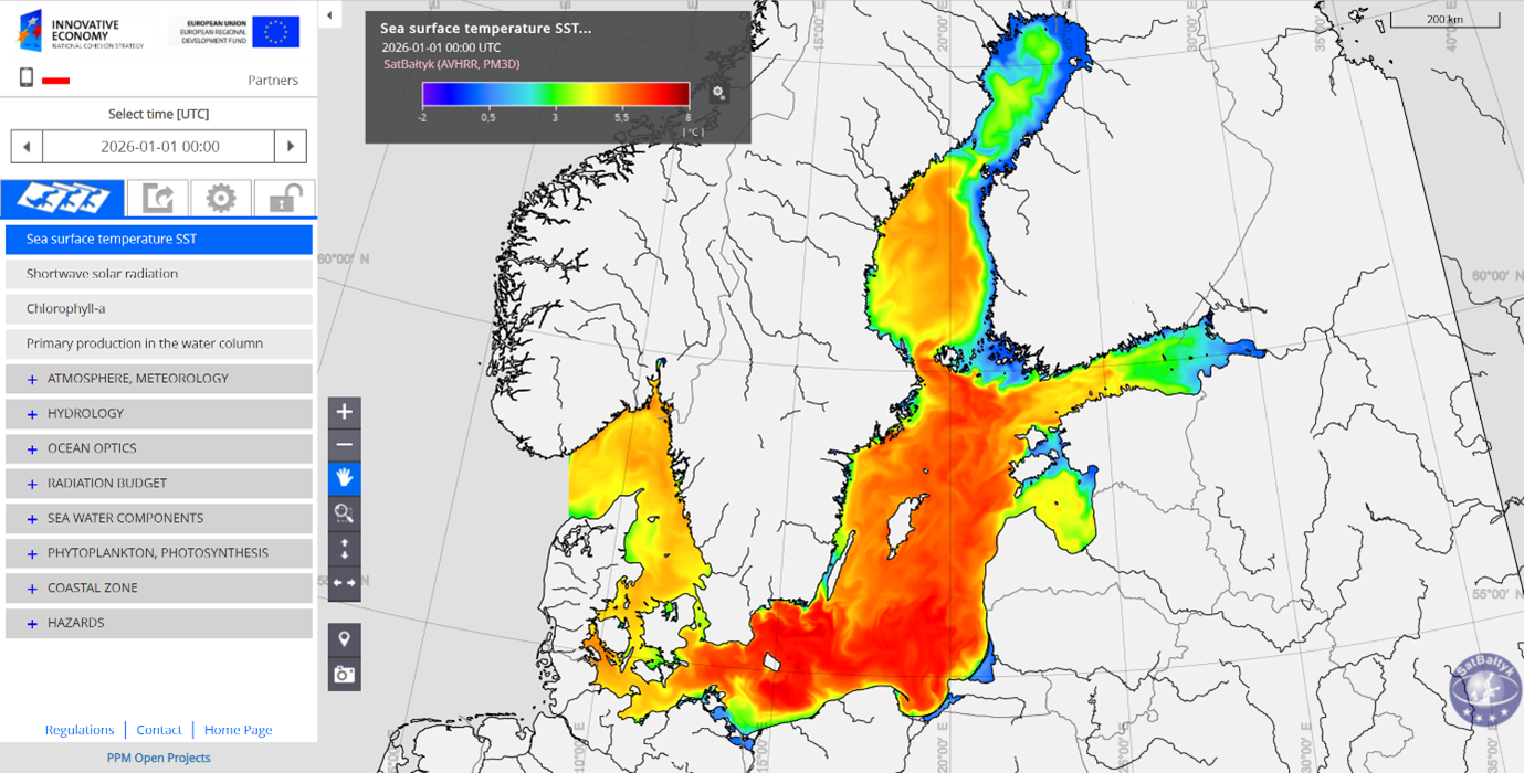
Picture 1. SatBałtyk 1 January 2026
Turning Satellite Data into Actionable Ocean Knowledge
The Baltic Sea is one of the most intensively studied yet environmentally vulnerable marine regions in the world. Eutrophication, harmful algal blooms, climate change, and strong land–sea interactions create a complex system that demands continuous, high-resolution monitoring. SatBałtyk was designed precisely to meet this challenge by transforming satellite observations into reliable, operational information products tailored to the Baltic Sea’s specific conditions.
At its core, SatBałtyk integrates Earth observation data with numerical models and in-situ measurements to deliver near-real-time and long-term information on key marine parameters. These include sea surface temperature, chlorophyll-a concentration, water transparency, primary production, and indicators of ecosystem health. By combining multiple data sources into a coherent system, SatBałtyk enables scientists to move beyond raw satellite imagery towards validated, policy-relevant marine information.
A Dedicated System for the Baltic Sea
What sets SatBałtyk apart is its regional focus and scientific depth. Rather than applying generic global algorithms, the system has been specifically adapted to the optical and biogeochemical characteristics of the Baltic Sea, one of the world’s most optically complex waters. This regional optimisation significantly improves data accuracy and usability, making SatBałtyk a trusted tool for both scientific research and operational applications.
The system supports a wide range of users, from marine scientists studying ecosystem dynamics and climate impacts to environmental agencies responsible for monitoring water quality and implementing European marine policies. In this way, SatBałtyk directly contributes to evidence-based marine management and strengthens the science–policy interface in the Baltic region.
Supporting Scientific Excellence and Collaboration
SatBałtyk exemplifies EurOcean’s mission to promote scientific excellence through collaboration and shared infrastructure. The system brings together expertise in satellite remote sensing, physical and biological oceanography, modelling, and data validation, fostering interdisciplinary cooperation across institutions and disciplines.
By integrating Earth observation, in-situ measurements, and modelling, the system enables harmonised datasets and long-term time series that are essential for detecting environmental trends, supporting climate research, and advancing regional and pan-European marine studies.
From Research to Policy and Public Services
Beyond research, SatBałtyk plays a crucial role in operational environmental monitoring and policy support. The information products generated by the system contribute to assessments required under European frameworks such as the Marine Strategy Framework Directive and support regional cooperation in the Baltic Sea.
Moreover, SatBałtyk’s outputs are designed to be accessible and usable beyond the scientific community. By translating complex satellite data into understandable indicators and visualisations, the system helps bridge the gap between science, policy, and society. This aligns closely with EurOcean’s commitment to outreach, transparency, and the societal relevance of ocean science.
A Sustainable and Forward-Looking Approach
Sustainability is embedded in SatBałtyk’s long-term vision. By relying on satellite observations and integrated modelling, the system enables large-scale, continuous monitoring with a relatively low environmental footprint compared to traditional observation methods alone. Its emphasis on data reuse, long-term time series, and operational continuity ensures that scientific investments deliver lasting value.
As satellite missions evolve and data volumes grow, SatBałtyk continues to adapt, incorporating new sensors, improving algorithms, and strengthening links with European and international Earth observation initiatives. This forward-looking approach ensures its continued relevance in a rapidly changing technological and environmental landscape.
Opportunities for the EurOcean Network
For the EurOcean network, SatBałtyk offers a compelling example of how regional Earth observation systems can complement broader European research infrastructures. Opportunities exist for knowledge exchange, joint research projects, training of early-career scientists, and cross-regional comparisons with other European seas.
SatBałtyk is more than a monitoring system: it is a bridge between satellite technology, marine science, and societal needs. By delivering robust, region-specific information and fostering collaboration across disciplines and borders, it contributes directly to a more informed, resilient, and sustainable relationship with the Baltic Sea.
We warmly acknowledge the SatBałtyk team and its partners for their continued efforts and vision. Their work highlights the power of integrated Earth observation systems in advancing ocean science and supporting evidence-based marine governance, values that lie at the heart of EurOcean’s mission.
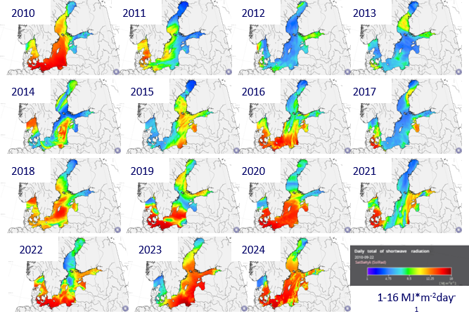
Fig1_dayily_doses_of_radiation
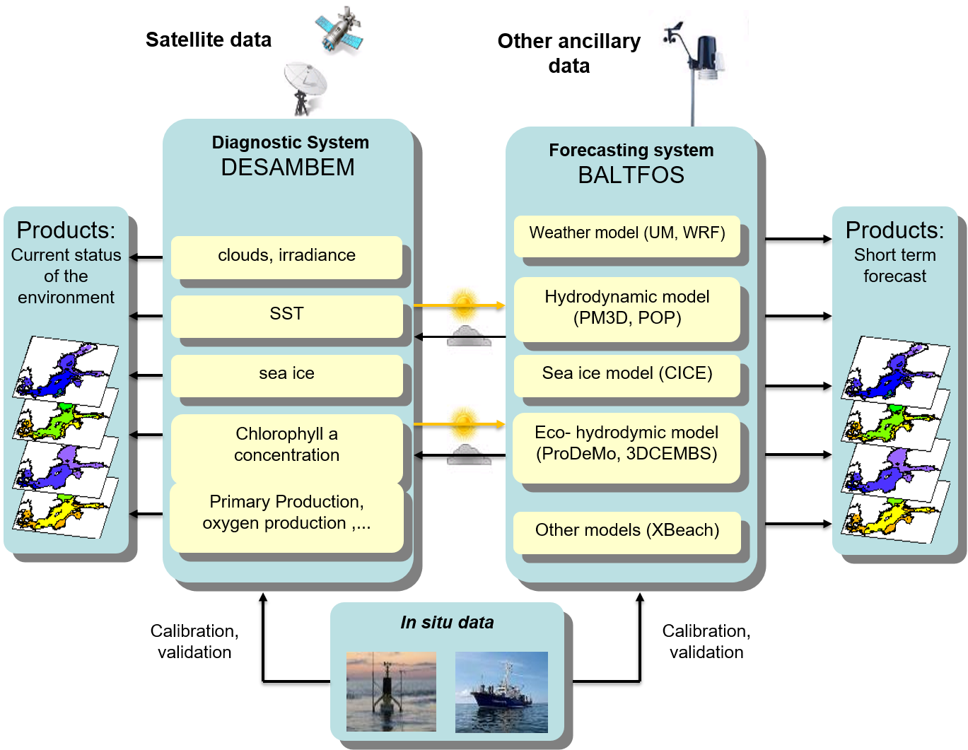
Fig2_SatBaltyk System block diagram